

Wind Measurement System
BreezeDude

Know exactly which way the wind is blowing.

BreezeDude

Anyone who flies knows: Between “The wind should be fine” and “The wind is right” lies a crucial difference. BreezeDude shows current wind conditions where they truly matter—right at the launch site.

The system measures wind speed, wind direction, and gusts and automatically transmits the measurements via the open FANET radio network. This allows current wind data to be transmitted from the mountain over long distances to compatible receivers and ground stations—and from there, if required, via the Open Glider Network (OGN) to the internet.

Behind this simple principle lies a sophisticated overall system: wind sensor, intelligent transmitter, energy-efficient radio transmission, and ground station work together seamlessly.

The BreezeDude Mini is designed for exceptionally energy-efficient operation and, thanks to its solar power supply, can be used continuously even in remote locations. Modern ultrasonic wind sensors enable the measurement of without mechanically moving parts - reducing wear and maintenance requirements.

A dedicated BreezeDude ground station connects FANET to the internet. Where suitable OGN infrastructure already exists, it may also be possible to use it. With a clear line of sight, radio ranges of 30 kilometers or more are possible between the transmitter and the ground station.

BreezeDude is intentionally open rather than proprietary designed: open-source firmware, FANET, standardized interfaces, and connectivity to existing community networks create a system that can be expanded and adapted to different requirements.

This makes BreezeDude an attractive solution for paragliding and hang-gliding clubs, flight schools, launch-site operators, and pilotswho do not want just any weather reading from the region, but the wind where takeoffs and flights actually take place.

BreezeDude brings real-time wind data from the launch site directly to the pilot—connected and free from recurring data subscription fees.
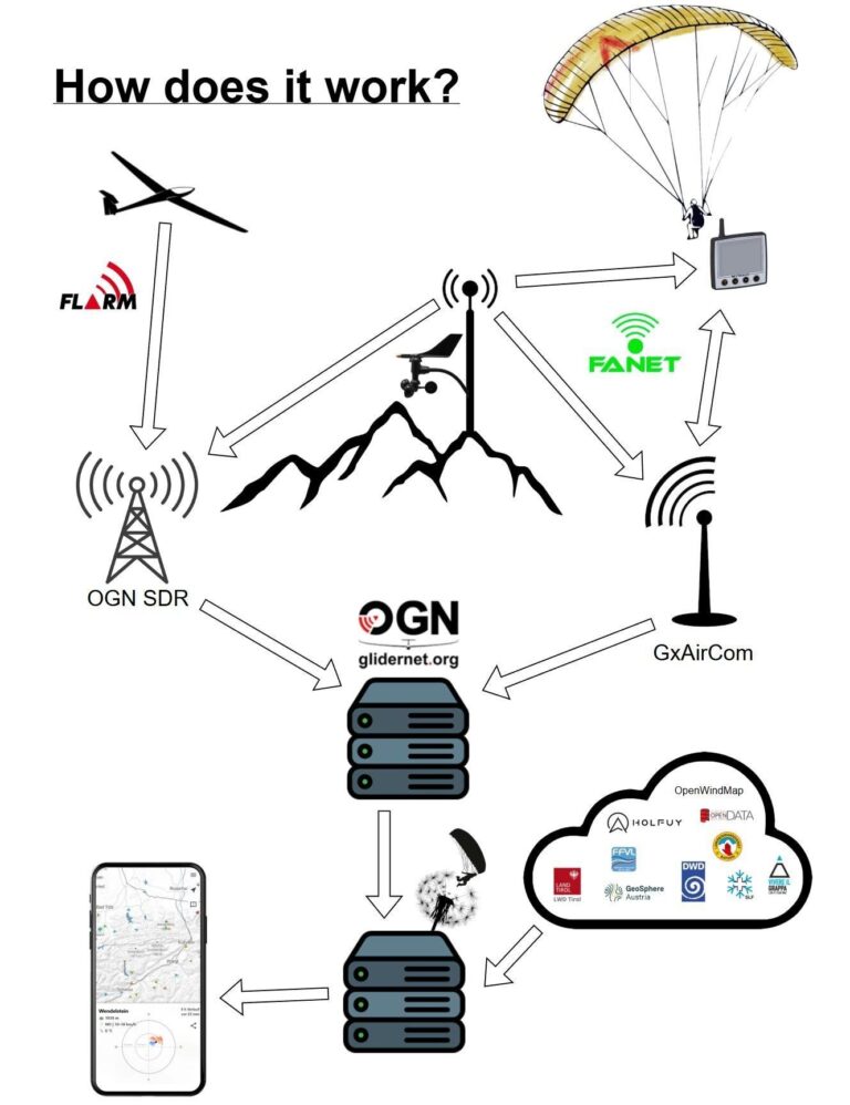

BreezeDude collects current wind and weather data at the site and transmits it via FANET. FANET-enabled flight instruments can receive these measurements directly. In addition, ground stations such as GxAirCom or OGN-SDR forward the data via the internet to the Open Glider Network. The BreezeDude server combines these readings with data from other weather services. All information is then clearly displayed on a map for smartphones and web browsers. The corresponding software is available at: githup repo

FLARM
FLARM is a radio-based collision warning system that exchanges position and movement data between aircraft.
It is not designed to transmit wind data and therefore does not communicate directly with BreezeDude.
BreezeDude collects local weather data and transmits it using the open FANET protocol.
Compatible ground stations can receive both FLARM and FANET signals and forward them to the OGN.
This allows FLARM traffic information and BreezeDude wind data to complement each other within shared applications.

OGN-SDR
– OGN = Open Glider Network
– SDR = Software-Defined Radio (software-defined radio receiver)
OGN-SDR is a software-based radio receiving station for the Open Glider Network.
It receives measurement data transmitted via FANET by wind measurement systems such as BreezeDude.
These include wind speed, wind direction, gusts, and other weather data.
The ground station processes the radio signals and transmits the data to the OGN via the internet.
From there, they can be displayed almost in real time on maps, websites, or in applications.

glidernet.org
glidernet.org is the central online platform of the Open Glider Network (OGN).
A wind measurement system such as BreezeDude records wind direction, wind speed, gusts, and other data.
The measurements are transmitted via FANET to an OGN ground station within range.
The ground station then forwards the data via the internet to the OGN server infrastructure.
There, the data is made available to maps, websites, and applications for near-real-time display.

FANET
FANET stands for “Flying Ad Hoc Network” and is an open radio protocol for direct data exchange.
A wind measurement system such as BreezeDude uses FANET to transmit its weather data wirelessly.
The transmitted data includes wind direction, wind speed, gusts, and temperature.
FANET-enabled devices and ground stations within range can receive these measurements directly.
Ground stations also forward the data to the OGN, where it becomes available online.

GxAirCom
GxAirCom is an open radio solution for communication via FANET and the Open Glider Network.
When used with BreezeDude, it can serve as a ground station to receive the transmitted wind and weather data.
These include wind direction, wind speed, gusts, and temperature.
When an internet connection is available, GxAirCom transmits this data to the OGN.
This makes the measurements available to compatible maps, websites, and applications.

Explanation of the diagram

The diagram illustrates two converging data paths: the tracking of aircraft movements and the transmission of wind measurements. Both types of data are fed into a shared map application via radio receivers and internet servers.

1. Flight and position data

  • The aircraft transmits via FLARM position and movement data at regular intervals.
  • One OGN-SDR-Groundstation receives these radio signals and forwards them via the internet to the Open Glider Network .
  • FLARM is used for collision avoidance and flight tracking—not for wind measurement. FLARM - How It Works

2. Wind measurement station on the mountain
The station in the center of the image represents a system such as BreezeDude. The wind sensor measures in particular:

  • Wind direction
  • Average wind speed
  • Wind gusts
  • Depending on the sensor, also temperature, humidity, and atmospheric pressure

The transmitter processes the measurements and transmits them together with the station’s location via FANET. BreezeDude typically transmits the data at regular intervals.

3. Direct reception via FANET
The wind data can be received in two ways:

  • A pilot’s FANET-enabled variometer or display device receives the data directly via radio. No internet connection is required.
  • A ground station such as GxAirCom or a suitable an OGN-SDR receiver receives the FANET data and forwards it via the internet.

The bidirectional arrows next to the aircraft indicate that, in addition to weather information, FANET can also exchange position data and other network data between compatible devices. GxAirCom

4. Open Glider Network
The upper server stack with the OGN logo represents the server infrastructure of glidernet.org. It collects the data transmitted by the ground stations and makes it available to connected applications.

These include different types of data:

  • FLARM and other aircraft position reports
  • Ground station status information
  • weather station data received via FANET

OGN therefore serves as the central interface between radio reception and internet applications. Open Glider Network

5. BreezeDude server and smartphone
The lower server with the paraglider/dandelion symbol represents the data platform behind the BreezeDude map. It receives:

  1. FANET weather data from the OGN,
  2. measurements from additional internet sources in the cloud.

The various data formats are consolidated and prepared for display on the map. The smartphone can then display stations, current wind readings, gusts, wind directions, and trends over time. BreezeDude - Data Flow

Neomium
Privacy Overview

This website uses cookies so that we can provide you with the best user experience possible. Cookie information is stored in your browser and performs functions such as recognising you when you return to our website and helping our team to understand which sections of the website you find most interesting and useful.